Jan 05, 2018
Among idyllic locations to live and work, being nestled among the mountains comes to mind; but suppose there are no terrestrial internet services available, what are the options? The natural solution is to turn to satellite for connectivity, but in a mountain valley, there may be no clear line-of-sight to any satellites that can provide service. What then?
Recall the recent hurricanes that devastated several islands in the Caribbean, including Puerto Rico and the Virgin Islands. With destroyed infrastructure, how will first responders be supported? How will civilian and government managers and workers be provided with internet until the infrastructure is restored? Conventional broadband satellite certainly has a role to play, but are there other options?
Ideas in Development
The European Space Agency (ESA) has been exploring ideas to solve such problems for the last 20 years, and now those ideas are becoming real. Various platforms called High Altitude Pseudo-Satellites or HAPS, look like a “missing link” between drone aircraft and satellites. These new aerial vehicles, sometimes referred to as High Altitude Platforms, fly or float at very high altitudes, similar to conventional aircraft, but they operate like fixed satellites. These craft are designed to stay in position for weeks or months at a time, providing users below with full coverage. HAPS can be thought of perhaps, as a deployable wireless antenna tower – 20 km tall!
The maturation of various new technologies has made this possible, including high-performance solar cells, lightweight batteries, miniaturization of avionics and sensors, and most of all, high bandwidth communication links that are cost-competitive with other options. The HAPS will operate about 20 km, (12 miles) well above the jet streams and clouds, as well as outside ground based air traffic control except during ascent and descent. At these heights, wind speeds are low enough that HAPS can hold their positions for extended periods. From this vantage point, they can provide services to a horizon about 500 km (310 miles) away. Consider our client nestled in the valley between mountains that block the view to the satellites above the equator. HAPS can be deployed above the mountains where it has a clear line of sight to the bottoms of the valleys. Intentional placement of HAPS provides the ability to deliver services to an area of interest with minimal concern about obstructions.
A number of firms are developing various vehicles, services, and the payloads to support them. ESA fostered an inaugural workshop, including over 200 HAPS experts. The experts spoke about the opportunities, along with the challenges and critical issues to address in order to complement current satellite services. ESA is interested in applications that complement its satellites, and that contribute to accelerating space technologies.
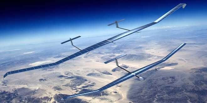
Early adopters include the Airbus Zephyr. These lightweight solar powered UAVs were originally developed by the company QineitQ in Britain. They are now part of the Airbus HAPS program. The Zephyr set an official endurance record on a flight from July 9 to 23 in 2010. The unrefueled, unmanned aerial vehicle flew for over 336 hours. It is made of a carbon fiber construction, and uses sunlight to charge a lithium-Sulphur battery during the day (recall that it is above the clouds) and the battery powers it at night. Airbus claims that replacing a conventional UAV with one Zephyr, would save 2,000 tons of fuel per year. Airbus anticipates that it will be able to fly for up to three months at a time.
Zephyr’s goal is to deliver voice and data communications, as well as high resolution optical imagery. The HAPS can be used to provide internet coverage to remote areas, as well as RADAR in order to provide real-time mapping, internet access, and surveillance within a broad range of applications. Airbus anticipates a family of Zephyrs optimized for different missions.
Another entry is the lighter-than-air StratoBus from Thales Alenia Space. At first glance, this solution might seem similar to Google’s Project Loon, which is based on high altitude balloons, however the Loon solution is not fixed in place, and new balloons must be continually released, as air currents move them away from the target. Like the Zephyr, StratoBus will maintain complete autonomy from a fixed position.
Designed to last for five years, StratoBus is easily transported to where it is needed. It remains in contact with a ground station where it is available for missions, day and night. Among those are border surveillance, toxic spill discovery, maritime vessel tracking, erosion, beach cleanliness and a host of other observation-based applications. StratoBus will support mobile internet, and reinforced connections in deserted or difficult to reach areas. It is designed to act as a complement or go-between for satellites and locations on the ground.

The StratoBus platform will be 70 – 100 meters long, and 20 – 30 meters in diameter. Featuring a number of technical innovations, StratoBus will use a unique method to capture the sun’s rays in all seasons, a Thales patented solar power amplification system and fuel cell technology for energy storage. StratoBus will maintain its position leveraging an aerodynamic design, and using two electric motors that will automatically adjust power to adapt to changing wind conditions. The first prototype is expected to test by 2021.
Let’s take a moment to consider the interesting array of satellite technologies and solutions that are being developed, which are changing the satellite industry, and see where HAPS fits in. These advances are often referred to as “NewSpace,” an umbrella term that refers to a fast-growing high-visibility interest in the commercialization and opportunities for private space flight.
HTS – First, and actively being deployed, are new HTS (High Throughput Satellite) GEO (Geosynchronous Earth Orbit) satellites that will continue to deliver video and data services at lower prices using powerful new Ku and Ka-band satellites.
NGSO – Next we have NGSO (Non-Geosynchronous Orbit) satellites deployed and under development, that will operate at low and mid-earth orbits and have the ability to provide high speed internet services – however these services currently require expensive tracking antennas to be used on the ground, since they are not fixed in position like GEO satellites.
FPA – Concurrent with NGSO satellites, antenna technology, particularly Flat Panel Antenna (FPA) technology is also advancing rapidly, with some vendors implementing new metamaterial technology in hopes of pulling down costs, lightening the antenna and increasing efficiency. New FPAs must track stationary and moving satellites, as well as track multiple satellites at the same time.
HAPS – Finally, HAPS, acting much like fixed satellites, will be able to deliver targeted broadband high capacity wireless services like WiMax, which requires much less power than satellite for a given amount of capacity. From their high vantage point, maintained by drone technology, they will overcome many line-of-sight issues for specific areas or projects. As a mobile solution, they can be used where and when needed; as a temporary service, or a permanent one that refreshes the HAPS platform periodically, to continually provide service.
The HAPS solution is very low-latency, and provides a directed service from a fixed location. Unlike satellites, they can return to the ground for maintenance and updates. HAPS are also multi-purpose, supporting a wide range of government and social applications when outfitted with RADAR or high definition video cameras. It’s not a stretch to consider new FPA (flat panel antenna) technology currently being developed to work with LEO and GEO satellites being placed on HAPS aerial vehicles, so that they can connect via wireless with users below, and with one or more satellites above.
Whether having so many choices might be considered good news, or bad news – given the need to analyze and evaluate multiple options, the forecast for the industry includes more flexibility and solution options… Pricing, of course will matter. Will HAPS simply fill a niche market, or will they be able to compete with other telecom options for wider markets? ESA’s HAPS are headed into the wind, and expect to hold their position.